Resources
Drone Test

Maybe you’ve seen the pictures of our drone already, or maybe this is completely new to you, but we’ve been busy working on a new fun project. It’s taken us out of the office, all over Del Mesa, and up a couple of trees in Bark Park, and we’re ready now to tell you all about it – and what we’ve learned in the process.
First of all: this was a project for a friend, who came to us with the idea of using drone technology for applications in the roofing industry, but he didn’t have a clue what would be possible with the technology on the market – and he didn’t have a drone he could test his theory out on.
Naturally, any opportunity to test out technology is an opportunity we dive straight into.
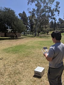
We borrowed a drone from DJI Drones, found a park near us, and armed with a beautiful clear day and a handful of scribbled schematics, we tried to understand how you can use drones to scan and record an image of an uneven landscape.
What the drone needed to do was fly 300 feet into the air and follow simple directions. Hypothetically, it could work using Google Maps and a custom-built app that would guide the user on how to plug in their address and fly the drone right above their home’s centre point; from there, the drone could take scans of their entire roof area, and then return to a safe landing point all on its own. Simple, easy, and smart: the roofing industry, revolutionised and safer for everyone involved.
The first problem we ran into was handling the drone. This was our first drone project, so the technique we had was to use the manual controller and try to guide it as high up as we could, using trees for reference points, but handling a drone requires a kind of movement that isn’t intuitive unless you’ve done it before. A few false starts, and we did manage to get it flying straight and mostly steady.
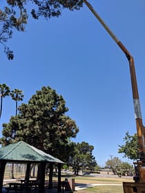
Normally, we’d have figured out the rough sketch of the drone path in the office, with the benefits of computers that can do lightning-speed mathematics and figure out the flaw in our flight path. For this project, we needed to be outside, handling the drone manually, to see how it would work to scan a rooftop. Our initial idea was to use the drone’s sensor to lift itself up, but that was relatively risky – and once the drone got stuck in a tree, we figured out that maybe there had to be a better way.
We tried flying it remotely, using the script function that came bundled in with our model which allowed you to plug in GPS coordinates and let the drone fly without any more input from you. We tried seeing how it worked in different weather conditions: Costa Mesa has pretty sunny weather for the most part, but wind would affect how the drone handled.
Once we had the basics down, we could do the rest of the simulation runs in our office, safe from underlying trees and confused dog walkers, but those days in the park were crucial for us. Drones handle differently to what we expected, and those expectations changed the way we were going to approach the project. Now that we had a deeper understanding of how drones worked, their limitations, how they handled, and the ease with which they could get lost, we had to go back to the drawing board.
To be honest, we’re still not 100% sure on how we’re going to work this project. The possibilities are limitless, and we need some more time working on it to understand where the problems are going to be, but we’re off to a good start.
One thing we did learn from this: you can never really try enough things. While projects that work right the way you expect them to work are valuable and good, sometimes having a project that doesn’t work immediately is better. It lets you see where everything you know and everything you expect meet, and how to bridge the gap between those points. Like Aristotle said, ‘the more you know, the more you realise you don’t know’.
Back to the drawing board for us. And hey: we got the drone out of the tree! Time to follow up our experimental week with a round of drinks at the Goat Hill Tavern.